
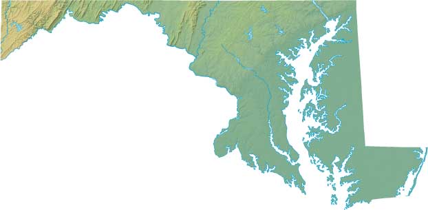
Maryland Relief Map
Static Maryland Relief Map
Interactive Maryland Relief Maps
The interactive relief map choices include a standard Google terrain map and an enhanced Google terrain map with Street View capabilities. To zoom in or out on either of these Maryland maps, click or touch its plus (+) button or its minus (-) button, respectively. To pan either map in any direction, simply swipe it or drag it in that direction. To display either of these Maryland terrain maps, click or touch one of the following menu options.
Maryland's highest mountain is Backbone Mountain, whose peak is 3,360 feet above sea level. The largest lake in Maryland is Deep Creek Lake. If you are planning a visit to Maryland, please see Visit Maryland, the official state tourism site, where you can find a wide range of travel and vacation information. For information about Maryland history and recreational activities, visit the following National Park sites.
Maryland National Parks
- Antietam National Battlefield
- Antietam National Cemetery
- Appalachian National Scenic Trail
- Assateague Island National Seashore
- Baltimore-Washington Parkway
- Catoctin Mountain Park
- Chesapeake & Ohio Canal National Historical Park
- Chesapeake Bay Gateways Network
- Clara Barton National Historic Site
- Fort Foote Park
- Fort McHenry National Monument
- Fort Washington Park
- George Washington Memorial Parkway
- Glen Echo Park
- Greenbelt Park
- Hampton National Historic Site
- Harmony Hall
- Monocacy National Battlefield
- Oxon Cove Park and Oxon Hill Farm
- Piscataway Park
- Potomac Heritage National Scenic Trail
- National Capital Parks-East
- Thomas Stone National Historic Site
Copyright © 2005-2024 State-Maps.org. All rights reserved.
Maryland-Map.org is a State Maps reference source.
To facilitate browsing, certain external links will open in new windows.
Maryland-Map.org is a State Maps reference source.
To facilitate browsing, certain external links will open in new windows.